

With urbanisation on the rise, the future resilience of cities will depend on the efficient and sustainable use of the groundwater reserves beneath them. Stephen Foster, Radu Gogu and Julia Gathu discuss the impact of groundwater misuse, and call on all parties to support better monitoring of this essential resource.
Urbanisation is the predominant global phenomenon of our time. For the first time in human history, more than 50% of the global population lives in cities, with 2,000 million more urban dwellers expected in the next 20 years. This underlines the need for cities to make more effective use of subsurface space as an essential element for their future efficiency, sustainability and resilience. But all too often, city planning operates in only two dimensions and fails to include informed consideration of the subsurface.
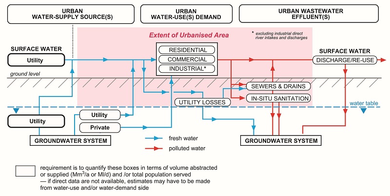
The consequences of this are far reaching in economic, environmental and social terms. In particular, poor appreciation of ground conditions – especially failure to consider groundwater and the dynamic factors controlling it in urban infrastructure planning and design (Figure 1) – is recognised as the largest cause of construction project delay and cost overrun, and of subsequent damage to urban infrastructure.
Causes of unstable water tables in urban areas
Unstable urban groundwater conditions, associated with either a falling or rising water table, can have a number of origins and impacts.
Falling water table
Intensive water well pumping for public and private water supply is the commonest cause of aquifer depletion. This initially impacts water well users themselves because of decreased yields and, sometimes, by up-coning of saline water from below. Numerous examples of this can be found worldwide, for example in Nairobi, Kenya (see box, opposite). There are also some successful initiatives to mitigate the problem, for example in Lima, Peru.
Water table decline may also have ecological consequences for local surface water features. In some circumstances, it may also cause land subsidence (by compacting interbedded aquitards), causing serious damage to building foundations and subsurface infrastructure, with increased flood risk and disruption of sewer systems. An example of the serious impact of continuously falling urban groundwater levels, associated with excessive water well abstraction, occurred in Bangkok, Thailand, between 1975 and 1995 (see box, p60).
Rising water table
The cessation of groundwater pumping as a result of demand relocation or pollution is the commonest cause of major water table rebound. This is often accentuated by increased aquifer recharge from in-situ sanitation, and leaking water mains and sewers. Water table rebound can cause inundation and/or damage to subsurface infrastructure (such as building basements and transportation systems) and malfunction of sewerage systems and in-situ sanitation, resulting in health hazards. It may also result in the mobilisation of pollutants from land contaminated by industry into groundwater.
An illustrative example of the damages and hazards resulting from unpredicted water table rebound occurred in Buenos Aires, Argentina, between 1985 and 1995. Excessive wastewater flows to sewage works because of groundwater inflow is quite a common problem in cities underlain by shallow aquifers, for example Bucharest, Romania (see box, p61).
In addition, major engineering of rivers passing through cities can cause either falling or rising water tables according to their hydraulic connection with the shallow groundwater system. In London, UK, plans to use the then newly constructed Thames tidal barrage for half-tide amenity control, rather than simply for surge-tide flood protection, had to be abandoned in the 1970s. This was because it was realised that it would bring about a permanent rise in alluvial groundwater levels, which would have inundated innumerable unprotected subsurface structures.
Urban groundwater quality hazards
Groundwater pollution in urban areas arises from a range of sources. Their relative importance will vary widely with the type of city and its stage of economic development. Sources will commonly include: in-situ sanitation systems, leaking sewers and sub-standard domestic effluent disposal; industrial effluent disposal, and accidental chemical and fuel spillage to the ground; and mobilisation of water pollutants from industrially contaminated land. Other common sources are: leaching of nutrients/ pesticides from cultivated and recreational land, and overuse of herbicides for weed control; and ineffective urban drainage systems.
Poorly controlled water well drilling and inadequately completed water wells can result in the rapid transfer of groundwater pollutants from shallow to deep aquifers.
Groundwater pollution will be of greatest concern to water service utilities that use urban water wells as part of their public supply system. So they require systematic water quality monitoring to meet a number of objectives. One is to fulfil legal obligations and reassure customers regarding potable water quality. Others are to underpin operational decisions by assessing trends and providing action trigger levels, and to evaluate the effectiveness of groundwater protection measures. There is also increasing concern about groundwater pollution with some so-called ‘emerging contaminants’.
Urban groundwater quality is a particular concern for developing cities where water service utilities are highly dependent on water wells in relatively shallow unconfined aquifers that are subjected to substantial subsurface contaminant load from in-situ sanitation. This is the case in Lucknow, India, and Natal, Brazil. But groundwater quality should be of equal concern to public health authorities in cities where large-scale private water well use, especially from shallow aquifers, occurs for potable supply, for example in Aurangabad, India, and Fortaleza, Brazil.
Relevance to urban stakeholders
As a result of all the above hazards, it will be clear that urban groundwater conditions should be of serious concern to numerous ‘active’ and ‘passive’ stakeholders including:
- Water service utilities, which depend on groundwater (to a greater or lesser degree) for drought reliable water supply sources
- Municipal engineering departments and private engineering companies, responsible for designing and constructing transportation facilities, storage basements and building foundations, who are concerned about ground stability and drainage, and who use groundwater for irrigation of recreational spaces
- Private in-situ water well users trying to counteract water supply shortages and high utility water supply tariffs
- Public health authorities concerned about the quality of groundwater used for private supply by city residents and for sensitive food industries
- Urban sanitation authorities (not always water service utilities) that have to consider groundwater inflow to sewers constructed below the water table, potential groundwater contamination by leaking sewage systems, and whether in-situ sanitation will be feasible or desirable given the prevailing ground conditions and potable groundwater interests
- Urban drainage authorities, which need to consider the feasibility and desirability of permeable pavements and subsurface disposal of stormwater, and evaluate and manage the risk of ‘groundwater flooding’ because of rising water tables
- Private urban energy developers interested in using groundwater heat exchange pumps for space heating or air conditioning of large buildings.
The density of measurement stations and frequency of data collection for urban groundwater monitoring will vary between different city settings, according to hydrogeological complexity, the level of direct resource use, and the intensity of competing demands for subsurface space. However, some guiding principles for good monitoring practice can be defined, taking into account the ‘drivers’ for groundwater change at city scale, and the procedure for initial design of an urban groundwater monitoring network will then involve a number of stages (see box, below).
Provisions for more effective urban groundwater monitoring
Urban groundwater information is a critical dataset for the development of resilient cities. The needs of a wide range of urban groundwater stakeholders have to be addressed. So mechanisms need to be found to involve these stakeholders in promoting groundwater monitoring networks. Local water resources or environmental management organisations should normally lead this, but strong support should be mobilised from the public water services utility, city council engineering departments, geological survey organisations (where they exist) and academic centres.
While a number of positive cases do exist, urban groundwater hazards remain unpredicted and unmanaged, meaning that, in the end, they have to be dealt with as emergencies. The consequences of a widespread lack of detailed knowledge of urban groundwater dynamics are often extremely costly and a cause of serious social distress.
The future resilience of our cities will depend increasingly on the efficient and sustainable use – and stewardship – of urban groundwater. Furthermore, the planning and development of our cities, as they struggle
to meet their space, water and energy needs, will benefit enormously from urban groundwater monitoring systems and city-scale studies. City planners need to improve their understanding of groundwater, and consider how they can better integrate this aspect of the urban environment into the development process.
To meet this requirement, water resource management and/or geological survey organisations will need to develop robust temporal datasets on groundwater at city scale, which must then be accessible to urban planners in the water, energy and construction sectors. Some form of ‘urban groundwater help desk’ in water resource management and/or geological survey organisations is an excellent way of achieving this.
Acknowledgements
The authors thank Katharine Cross and Lisa Andrews (IWA Headquarters) for their very helpful comments on this article, and staff of the water utilities in Bangkok, Lima and Nairobi for information on their water supply operations.
Notes
a Foster S et al, 2010, GW-MATE Strategic Overview Series 2. World Bank (Washington DC) (via: www.un-igrac.org).
b Gray D A & Foster S S D, 1972, Philosophical Transactions Royal Society of London A 272: 245-257.
c Foster S et al, 2010, GW-MATE Strategic Overview Series 3. World Bank (Washington DC) (via: www.un-igrac.org)
The authors
Dr Stephen Foster is chair of the International Water Association’s Groundwater Management Specialist Group and visiting professor of groundwater science at University College London. He is also a co-chair of the Urban Groundwater Network of the International Association of Hydrogeologists and was director of the World Bank Groundwater Management Team during 2001-12.
Dr Radu Gogu is deputy chair of the International Water Association’s Groundwater Management Specialist Group and professor of groundwater engineering at the Technical University of Bucharest.
Dr Julia Gathu is secretary of the International Water Association’s Groundwater Management Specialist Group and operations manager of the NGO Drilling for Life in Nairobi, Kenya.
Nairobi, Kenya
The demand for water in Nairobi has increased substantially in the past 30 years. The urban water utility obtains its supply almost exclusively from the Ndakaini Reservoir, but operates a few water wells to supplement this supply in some suburbs. Current production exceeds 520Ml/day, but high distribution losses (approaching 50 per cent) and more frequent surface water drought episodes decrease the volume available to meet this demand.
While groundwater abstraction by the urban water utility commenced in the 1930s, private drilling by commercial, industrial and multi-residential users mushroomed from around 1990. By 2005, there were 2,200 operational water wells and this number is now believed to exceed 5,000. These water wells are capable of producing 400 Ml/d, although actual abstraction is believed to be 100Ml/day (35Mm3/year), which represents 25-30% of the total water supply actually available to users.
There remains doubt about the overall level of resource exploitation, given that natural aquifer recharge is estimated to be 25Mm3/year plus around 65Mm3/year from water mains leakage and infiltration from in-situ sanitation.
Current levels of groundwater abstraction have resulted in serious local resource depletion, with water levels falling 50-100m in the past 30 years or so, leading to much increased pumping costs and some yield failures. But there are increasing concerns about serious pollution from in-situ sanitation to the ground.
The cost of water well construction and completion (now usually to 250-350m depth) is US$25-35,000, including a pump valued at about US$10,000. But all new apartment and office block construction plans still prioritise water well installation, and well separations have progressively reduced to as little as 100m in some instances.
In recent years, the water resource regulator and urban water utility have begun to confront excessive (often illegal) water well drilling by private users, and they now recognise that Nairobi’s groundwater represents a strategic reserve for times of extreme drought and other emergencies.
When drilling a new private water well, it is now necessary to obtain a ‘no objection certificate’ from the water utility, a permit from the resource regulation authority, a construction certificate from the competent building agency, and pay a fee to local government. Moreover, drilling contractors are obliged to submit full water well construction reports to the appropriate ministry to qualify for the annual renewal of their operational license. However, groundwater use inspection and level monitoring remains insufficient to ‘fine-tune’ these policies.
Source: in part after Foster S & Tuinhof A, 2005, GW-MATE Case Profile Collection 13. World Bank (Washington DC) (via: www.un-igrac.org)
Bangkok, Thailand
Bangkok is built on thick alluvial and marine sediments that include a series of semi-confined aquifers overlain by the surficial low-permeability Bangkok Clay, which protects against groundwater pollution. Groundwater exploitation by the metropolitan water utility started in the 1950s, and abstraction (including by private industrial water wells) reached 500Ml/d by 1980, deploying water wells of 100-250m depth. From the mid-1980s, evidence of serious land subsidence (of 0.5-0.8m) resulting from aquitard compaction emerged. This caused damage to infrastructure, and increased the risk of flooding from tidal surges and saline water intrusion.
This situation led to the first groundwater management initiative between 1985 and 1995, in which the metropolitan water utility closed many water wells and imported treated surface water to the city. The resulting increase in water tariffs triggered a huge increase in private water well drilling by industrial, commercial and multi-residential users, on top of continued pumping by provincial waterworks, such that the total groundwater abstraction reached 2000 Ml/d in 1995.
The government’s groundwater resource department acted to reduce abstraction and halt subsidence. It: regulated and metered private groundwater use more closely; improved groundwater level and quality, and land subsidence monitoring; and levied structured charges for groundwater use, which reached levels of US$ 0.42/m3 in the most critical areas. Subsidence was mitigated by 2010. Now, 4,000 wells are mainly in use by around 3,000 private operators, extracting 1600 Ml/d, with provincial waterworks abstraction down to 5 per cent of the total.
Source: in part after Buapeng S & Foster S, 2008, GW-MATE Case Profile Collection 20. World Bank (Washington DC) (via: www.un-igrac.org)
Bucharest, Romania
Groundwater abstraction from Bucharest’s shallow aquifer was ended in 2000. A confined deep aquifer is now used for urban water supply.
Today, the main city-scale subsurface problems are produced by interaction between groundwater and the underground infrastructure: (a) the ‘groundwater flow barrier effect’ produced by the extensively canalised Dambovita River and the parallel underground railway tunnels (of 7-23m depth); and (b) major groundwater inflows to trunk sewers, which generate an excess sewer flow of about 1m3/s.
A partnership between the urban water utility and an academic centre led to groundwater investigation and modelling of the shallow aquifer system. This threw light on the problem of excessive sewer flows and subsurface structure flow interference, and involved a broad base of urban stakeholders in data collection and monitoring.
The groundwater monitoring system focuses on the first two aquifer layers (of shallow and intermediate depth) and is composed of 145 monitoring stations. Their distribution has a higher density in the centre of the city. The major subsurface infrastructure elements (subway line, deep foundations, etc.) are also closely monitored. Monitoring points are located along the extensively canalised river that cuts the city into two parts (increasing groundwater hydraulic heads) and around the artificial lake supplying water to this river.
The urban groundwater monitoring network constitutes an important milestone in hydrogeological understanding and represents a powerful tool for urban groundwater management. Future studies, design, and construction projects for urban subsurface infrastructure can now count on accurate groundwater information, recognising that many of these elements are closely connected with groundwater.
Source: in part after Gogu C R et al, 2017, Procedia Engineering (Elsevier) 209: 135-142
Designing urban groundwater monitoring networks
A range of needs should be considered when designing urban groundwater monitoring networks:
- Conserve groundwater resources as a public water source, so as to improve supply security under climate change stress
- Protect groundwater from excessive abstraction and contamination, where its use for public water supply constitutes a strategic reserve
- Avoid the risk of ‘groundwater flooding’ of subsurface structures by rising water table
- Redevelop securely contaminated land sites avoiding groundwater contamination
- Understand spatial/temporal water table fluctuations for design of subsurface facilities
- Regulate shallow groundwater use for geothermal purposes.
The design process then includes the following stages:
- Systematic analysis of basic information and preliminary study of groundwater use drivers and management issues
- Assessment of the groundwater monitoring capability and interests of existing stakeholders
- Network design considering the required spatial and depth distribution of water wells, and the extent to which new purpose-drilled observation wells or piezometers are required
- Installation and commissioning of the completed observation network
- Selection of measurement parameters, analytical determinands and sampling frequency
- Periodic review of monitoring data and network optimisation.
Source: in part after Bonsor H C et al, 2016, EU-COST Subsurface Action Working Group 2 Report (www.sub-urban.squarespace.com)


